Who Do You Think You Are?
Who Do You Think You Are? Magazine is produced by the BBC. Click here to subscribe.
The National Archives has teamed up with TheGenealogist to put its collection of tithe maps and apportionments online. Alan Crosby explains what these fantastic resources can reveal...
A major new online resource is now being launched, one which will potentially revolutionise research opportunities for family and local historians across England and Wales. The National Archives (TNA) has joined forces with TheGenealogist to put all their tithe maps and tithe apportionments online. This massive project will be introduced gradually because its sheer scale means that it has to be done in stages. When it's completed in 2015 one of our most valuable and extensive sets of key historical records will be available in a fully-searchable form, meaning huge savings in time and effort for a great army of researchers.
The key documents (the tithe maps and the apportionments - or schedules - which provide a comprehensive inventory of landholdings) will be uploaded in stages over the next 18 months.
What were tithes?
The tithe system dated back to before the Norman Conquest, and was a way of providing an income for the Church. It had become a major source of revenue by the 16th century but like any tax it was very unpopular with those who had to pay. It was also extremely complicated to administer, with all sorts of quirks and anomalies. Boiled down to essentials, it means that the owners and occupiers of land, and many small tradesmen and craftsmen, were legally obliged to give one-tenth of all their produce to the Church.
After the Reformation in the 1530s this meant the Church of England. It was completely irrelevant if you were an adherent of a different denomination - Catholics, nonconformists and anyone else all had to hand over assets to the Anglican church. The direct beneficiaries were the local parish clergy, because tithe goods went to them, not to the Church authorities. But even worse, in many cases private individuals - mainly great landowners - had acquired the 'tithe rights' so the benefits went to them, rather than to religious purposes.
Not unexpectedly, all this was a major source of discontent and created many grievances. Not only was it compulsory, but it meant that smallholders, farmers, major landowners and many 'ordinary people' saw a hefty chunk of their hard-earned produce going to a wealthy organisation or a rich individual. If you disliked the local vicar, hard lines! And one-tenth of meant just that - one in every 10 calves born to your cows, one in every 10 baskets of apples from your orchard, one in every 10 sheaves of wheat harvested in your fields.
The tithe system dated back to before the Norman Conquest
By the early 19th century the system had fallen into complete disrepute and though the Church authorities resisted fiercely any attempt to remove this ancient procedure, in the end they had to give way. The result was the Tithes Commutation Act of 1836, which reformed the whole basis of tithe-giving. It abolished the payment of 'goods in kind' and instead substituted a simple annual monetary payment based on the value of land. These payments were to be fixed in perpetuity - in other words, because of inflation their value would gradually dwindle over time and eventually they would become mere token sums.
The first step was to value the land involved, so that the payments could be assessed. That's where the tithe records come into the equation. The Act of 1836 established a body known as the Tithe Commissioners, based in London, who oversaw a massive exercise in surveying, valuing and recording landownership.
The tithe records
Not since the Domesday Survey in the mid-1080s had there been anything remotely like it. In about 75 per cent of the parishes and townships of England and Wales, a large scale mapping exercise was undertaken. The tithe maps, usually at a scale of 26 inches to the mile, were they key. On them was plotted every parcel of land that was subject to tithes, and in almost all cases the whole area of a parish was carefully recorded on a clear uncluttered map. These can be huge - maps 15 feet long and 10 feet wide are by no means unusual.
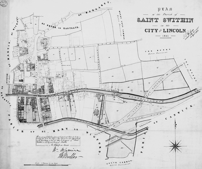
Greyscale images of microfilm copies of the maps (like this one) will be put online in the spring.
The maps are cross-referenced with the tithe apportionments, which were books or rolls of large parchment sheets on which were recorded, for every parcel of land, the following information: the name of the landowner; the name of the occupier (that is, the person actually 'using' the land); the reference number of the piece of land, also shown on the map; the name of the field or other parcel of land; the land use; the acreage; and the details of the valuation and the charges payable. These incredibly detailed surveys are among our most comprehensive records of land and how it was used, and they are potentially or immense interest and importance to local and family historians.
HOW THE NEW RESOURCE WORKS
Get the most from the three-stage, online release of apportionments and maps
The online resource is being introduced to TheGenealogist.co.uk in three stages. Find it on the homepage via the Polls, Electoral Rolls and Landowner drop-down menu.
First to be uploaded are the entire set of apportionments for the 11,830 tithe districts that were apportioned and mapped: 10,871 in England and 959 in Wales. These are fully searchable by forename and surname options and can be refined by county and parish, with a drop-down list of parish names. This takes you to the usual search results where you have options of clicking on a transcript of an entry, or the original image. The transcript is not the complete content of the entry but provides all the information that is needed by family historians. The original image is excellent quality and there is the facility to move backwards and forwards to previous or following pages.
The second stage will follow later in the spring. Greyscale images of microfilm copies of the maps will be put online, so references in the apportionments can be cross-referenced with the mapping and you can identify where individuals held land. And stage three, due in 2015, will replace these with specially photographed images of the original coloured tithe maps themselves.
Many individuals have multiple entries. I searched for one of my family names, Lucas in Norfolk, and of the 406 entries, no fewer than 246 were for one man, Gibson Lucas. He was a prosperous landowner and every one of his fields appears separately. This is because this indexing has included every entry in every apportionment - many millions of names.
The process of surveying, mapping and recording began almost immediately, and continued for about 15 years. The earliest completed tithe maps and apportionments date from 1837, the peak year were 1839-1843, and the last few were finished in the early 1850s. Each had to be signed off by the Commissioners and officially enrolled, and the date of the map and apportionment is the date when that enrolling was complete (so the actual survey might have been a year or so earlier).
There are roughly 11,000 separate sets of tithe records from England and Wales (the exercise did not involve Scotland), from and overall of about 15,000 parishes and townships. That means that about 73 per cent of the country is covered. In the other areas the tithes had already been abolished, either because a landowner has 'bought out' the tithes by paying a lump sum to the Church and then scrapping the system, or because a historical quirk meant that tithes were not levied in any case.
Three copies were made of the records for each parish (or township in the northern counties). One copy was deposited with the other parish records in the parish chest - though because the maps were so huge they wouldn't normally fit in the chest so were propped up beside it! The second copy was given to the appropriate Church of England diocese and would be housed in the diocesan offices adjacent to the cathedral. The third copy was sent to London for the records of the Tithe Commissioners. This last set of records, covering the entire country, eventually found its way into TNA.
The parish and diocesan copies are now usually found in county record offices, but because of the vagaries of history (and because of damp, fire, mould, vermin and neglect over the decades) quite a lot are either lost or are in poor condition. In contract, the third set is usually in excellent condition and, of course, this is much the most complete series that survives. Those are the ones that TheGenealogist and TNA are making available.
Genealogical Uses
How can family historians exploit this resource and what do the records tell us? Only a minority of the population is listed and named, so for many of us our ancestors won't appear. It's not like the census, because its primary purpose was the recording of land, not people. However, the tithe surveys appear around the time of the 1841 and 1851 censuses, so it is quite often possible to link the two sets of records.
The first key group involved is the landowners, large and small. If your forebears were owners of property they will almost certainly appear (unless of course they were in the 4,000 or so parishes not covered). The number of landowners varies dramatically from place to place. To take a specific example, the township of Poulton-le-Fylde in Lancashire had an area of only 962 acres but no fewer than 113 different landowners are listed in the tithe apportionment of 1840. Of these, 57 owned less than an acre of land, so were right at the bottom of the league table of ownership. Ten miles away at Lytham, however, the entire township of 5,500 acres was owned by one man, the squire Thomas Clifton.
Who were the 'occupiers'?
The second key group of people is the occupiers. They could also be owners - hence the term 'owner occupier' - but they also include the main tenants who worked the land or lived in cottages but paid rent to the landowner. For instance, in Yeardsley-cum-Whaley on the borders of Cheshire and Derbyshire, the tithe apportionments lists 13 landowners, by far the most important of whom was John William Jodrell, who owned roughly 85 per cent of the entire area.
Most of the others just had a few fields and one owner was the Peak Forest Canal Company. But the apportionment also lists 49 different occupiers, some of whom were substantial tenant farmers and others had a single rented cottage and garden.
So, family historians are statistically more likely to find forebears among the 'occupiers', but it is very important to check both columns. Among the people who are omitted entirely are those who rented sub-let property (in other words, somebody who rented a cottage from a tenant farmer or from an urban landlord would not appear in the schedules). Anybody who rented rooms, or did not have a formal lease, would not appear. And in congested urban areas tithe records will only show a small percentage of the total population. In effect, most of the lower orders are likely to be absent and the tithe documents are skewed towards the 'middle classes' and upwards.
But if you do find a forebear, you have hit gold, because you can then find out which land they either owned or occupied, or both. You can then look at the list in the schedule, then cross reference with the map and see exactly which fields and houses were those which you ancestor owned or worked 175 years ago. You can take an Ordnance Survey map and plot their holdings, you can see the extent of their farm or smallholding, and you see how they fitted into local society. Were they the 'top people' in the community, or just one of many small property owners?
It makes family history come alive, because you can connect the people and the place in a direct way. And then you can go there and lean over the wall and look at the fields (supposing they are not now a housing estate or a motorway) and think about those ancestors walking across those fields as proud landowners or, more likely toiling and labouring to make ends meet on their smallholding.
Watch out!
An individual might be listed as owner of many cottages and houses but might not have lived in any of them. Make sure you cross-check with the census.
Haworth Hamlet, West Riding of Yorkshire
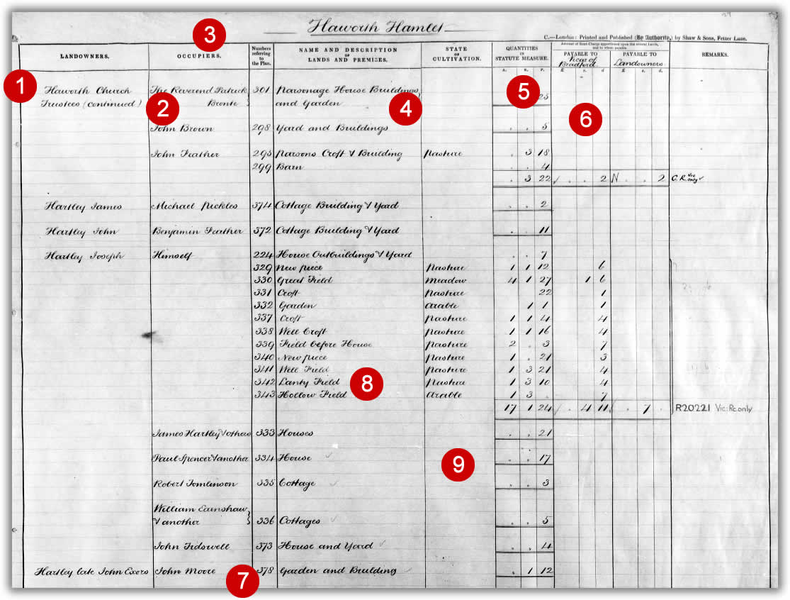
This is one sheet of the tithe apportionment for Haworth, in the West Riding of Yorkshire (enrolled on 28 February 1849). Haworth was an attractive but workaday village on the edge of the Yorkshire woollen district, which has been made immortalised by the legendary reputation of the famous Bronte family which lived there at the time the tithe survey was taken.
1. Landowners - The left hand column shows the name of the landowners, arranged in alphabetical order. The first on this page is the Trustees of Haworth Church.
2. Individuals - The first entry is for Reverend Patrick Bronte, father of the novelists Charlotte, Emily and Anne.
3. Occupiers - The second column gives the names of the occupiers.
4. Location - The Reverend Bronte was occupier of the famous parsonage, where some of the greatest works in English literature were being written. Jane Eyre had just been published when the tithe surveyors visited.
5. Quantities - This column gives the exact area of the land, in acres, roods and perches.
6. Parcel numbers - The figures in the third column are the parcel numbers, which cross-reference with the fields and properties on the map.
7. Parcel name - The name of each parcel is given in the fourth column. These are the field names for the agricultural land.
8. Farmland use - The fifth column states the use to which farmland was put (in this case, pasture, meadow or arable).
9. Payment - These columns show how the amount of tithe payments were determined, in pounds, shillings and pence.