
Discover Your Ancestors
Two critically acclaimed publications are available to family history researchers - the annual print magazine, Discover Your Ancestors, and the monthly online magazine, Discover Your Ancestors Periodical. Click here to subscribe.Charles Booth poverty maps added to TheGenealogist
TheGenealogist’s innovative Map Explorer, which allows family history researchers to trace an ancestor’s property and then view the changing environment over time, now boasts another powerful new feature.
While previously researchers were able to view the georeferenced Lloyd George Domesday Survey Data Layer of maps (see our other news below) and also see the sites of UK War Memorials, cemeteries and churchyards from across the country, TheGenealogist has now added the fascinating Booth Poverty Maps of London 1898-1899 to this useful resource. These reveal London streets classified by income and class.
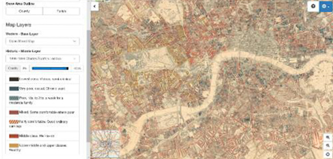
There were seven classifications detailed on Booth Maps ranging from the lowest to the wealthy. Those streets coloured black were for the ‘Lowest classes. Vicious, semicriminal’. Next was dark blue for the ‘Very poor, casual. Chronic want’. This was followed by light blue to indicate ‘Poor. 18s to 21s a week for a moderate family’. Streets in purple indicated ‘Mixed. Some comfortable others poor’. Those roads in pink were ‘Fairly comfortable. Good ordinary earnings’. Red designated a street inhabited by the ‘Middle class. Well to do’, while yellow the ‘Upper-middle and upper classes. Wealthy.’
Diamond subscribers to TheGenealogist can use the interface by clicking on the large map of England, Scotland and Wales on the main search page. The next screen allows the researcher to enter major street names or an area so that you can browse the locality.
TheGenealogist’s powerful Map Explorer has been developed to view these georeferenced historic maps overlaid on top of modern background maps including those from Ordnance Survey and Bing Street maps, as well as a satellite view. With the Map Explorer you can search for an ancestor’s property, even if the road has changed or gone.
Tower Hamlets 1910 Domesday records
TheGenealogist has just released the Lloyd George Domesday Survey records for Tower Hamlets which cover land owners and occupiers in 1910-1915 with over 91,500 individuals recorded. These now join the previously released data books and their detailed associated maps for other parts of London, bringing the total number to nearly half a million individuals within this record set.
This new release is the latest phase of TheGenealogist’s extensive ongoing project to digitise over 94,500 Field Books, each having hundreds of pages, and linking them to large scale IR121 annotated OS maps which are now viewable in TheGenealogist’s powerful Map Explorer tool (see also above).
This new release covers records made of property ownership and occupation in Bethnal Green, Bow, Bromley, Christchurch, Limehouse, Mile End, Poplar, Shadwell, Wapping, Whitechapel and other areas of the East End of London.